GeoBind
GeoBind® is the flagship product developed by GeoICON. Its a business integration middleware framework for rapid application development. The need for such a framework comes when organization find themselves with many sub systems like databases, application servers, files to be connected for a state of the art, spatial centric business applications.
The framework is middleware exclusively developed for open back-end systems enabling organization to be "open" in their approach and take full advantage of the sophisticated components that are available in the industry, without being vendor locked. At a very high level, GeoBind leverage on PostgreSQL/PostGIS as back-end database and GeoServer as Spatial Application Server.
Governments and commercial organisations all over the world can use GeoBind and build their next generation workflow driven enterprise application.
GeoBind Features
GeoBind provides full, enterprise-class GeoSpatial functionality that’s used by geo application users every day. The development of GeoBind is inspired by the users requirement, so we thrive to give the best and the most sought after functions, rather than building solutions as silos. Key features of GeoBind are considered below.
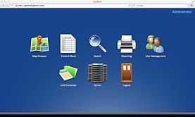
Web-Based Desktop UI
GeoBind provides the "industry first" web desktop environment for web driven enterprise applications. It is a unique concept and allows users to work on multiple sub-applications (modules) on a web browser and also the ability to interact between them. Users access all functionality via a web browser. No activeX controls, plug-ins, applets or downloads required.
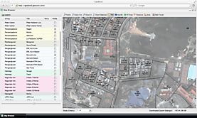
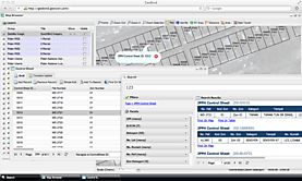
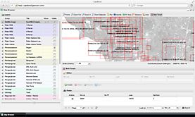
Map Navigation
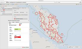
Includes pan, zoom, attribute information (unique multilayer), measurements. Layer arrangement can be customised by users. State of work could be saved as bookmarks. GeoBind provides the "industry first" unique layer management, layer transparency control, identify tool and many more. The navigation allows to integrate with data editing and the concept of data editing is one of major features of GeoBind.
Geo BI
Includes search, query builder, graphs and charts, parameterized reports, exports to Excel, and regional "drill-down".
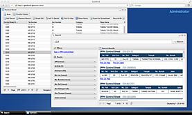
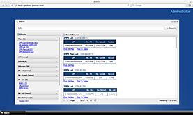
Enterprise Search
GeoBind provides the first and only one of its kind search functionality which make the middleware very versatile and different from the rest. Powered by the Apache Lucene and Solr the search is truly an enterprise class feature.
Search Integration
GeoBind search provides the ability to categorize search based on ranking. The search can span across multiple databases and the result can be directly linked to spatial features and non spatial features. This again is another unique feature of the middleware.
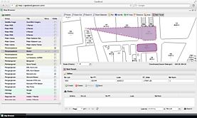
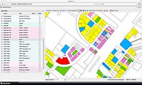
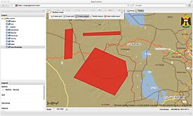
Spatial Editing
Full editing capabilities for the complete range of geometry features; a wide range of spatial editing functions like attribute entry, draw, move, delete, vertex editing, coordinate/ distance and angle entry, copy and paste, merge, split, rotate & graphic grouping. Includes session management, undo & redo, locking, and the ability to keep edits private until approved by a designated supervisor.
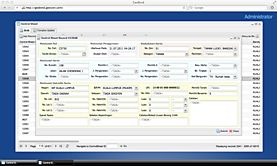
Data Editor
This is a JavaScript based thin client and has very light footprint. Schema driven web applications can be created with the state of the art user interface. Versioning and Data Auditing are integral part of the middleware.
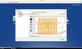
Printing
Map plotting with a user interface to customise print layouts. This includes the ability to deliver vector data in PDF files to the web browser for plotting to scale.
Styling
Administrators can define display and print map styles (including lines, fills, text and symbols & scale-dependency), and for users to define personal styles. Layers may be split by attribute.
Thematics
Users can define and display thematic queries, including by range, discrete values, database joins, and spatial & SQL functions.
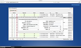
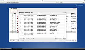
Role Based Access Control
GeoBind provides role-based access control for data sets, maps, print templates & functions. Access control for the web applications can be fully managed within the GeoBind middleware. Complex role based access to enterprise application can be made possible by its inbuilt unique feature.
Redline and Markup
GeoBind provide features of redlining and gives ability to put markup onto spatial data.
Auditing
GeoBind has an integrated audit feature to monitor the use of the application by the users, at various levels. The reporting functionality is truly an enterprise class and can produce multi-page PDF reports.
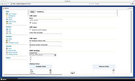
Web Administration
User-friendly web-based setup of spatial data from postgresql and geospatial web services, including definition of maps, styling and metadata.
Standards-based security
GeoBind security approach includes access control to data and functions by user role, and LDAP/ Active Directory support.
Metadata
View and search metadata to quickly find useful spatial data sets. Administrators may define metadata profiles corresponding to metadata standards such as ISO 19115 and custom profiles. This is done with the integration of GeoNetwork.
Technical Specifications
Database Server |
|
|---|---|
Application Server |
|
GIS Application Server |
|
Enterprise Search Server |
|
Authentication Server / Single SignOn |
|
Metadata Catalog |
|
Business Intelligence |
|
Supported OS |
|
Hardware Requirements
The web application server on which GeoBind is installed must have an Intel or compatible x86-64 64-bit CPU architecture.
Hardware requirements depend on expected user numbers, data sizes, usage patterns etc. GeoBind is typically deployed with separate application and database servers. Multiple application servers may be used for scalability and failover. Separate web servers may also be deployed.
A typical application server would have 2 X 2+core (2GHz+) 64-bit CPUs, 16GB+ RAM, 20GB+ Disk.
A typical database server would also have RAID disk array, > 100GB capacity.
To know more about our products, you can contact us through sales@geoicon.com or use our webform. Our consultants will attend to your queries soon.